A lot of the time when I go off onto an adventure, wherever it may be, the toughest part is describing it. I’ve talked about this before in other posts, so I won’t get into all that again. However, I will say that there is absolutely no better example of this than Katahdin.
I’ve spent more and more time in the North Maine woods over the years, mostly because of Camp Ernest Living, the Neville family cabin we’ve had for a year or so. The most impressive aspect of that part of Northern Maine is the absolute domination that Mount Katahdin holds over the skyline to the north. It rises over the land, like a great beast, overlooking everything. You can’t look anywhere north without the huge granite monolith towering over the flat land below. Looking up at that creature as you leave camp at five in the morning the day of the hike, is as demoralizing as it gets.
Something gets you in the car though. Rolling up on Baxter State Park, you’re always greeted by a long line of cars, most filled with other hiking pilgrims headed to the ultimate mecca of Katahdin. Letting only a certain amount of people into the Park allows the state to continue Governor Percival Baxter’s goal of keeping the area “forever wild” when he donated the land in 1930. Nine miles up the dusty Nesowadnehunk Tote Road, one of only a handful of roads in the entire park, got us to the Katahdin Stream Campground. There, you’ll find the trail head for the Hunt Trail, which leads you 5.2 miles up (and then up some more) to the summit of Baxter Peak.
So, at around 6:40am our ragtag group headed out. I had my doubts from the beginning. Our group consisted of myself, my Uncle Billy the retired Army member who’s diet consists of red meat and beer exclusively, my other uncle, Ryan, who has recently became a fitness guru as of late, my dad the retired Marine Corps war veteran who did it with me last year and really had to grind it out, and my 10 year old cousin Owen. We faced around 4,000 feet in elevation gain, and ten hours of hiking.
Ok, so boom, we’re off. We sign in at the official trailhead, and head up the trail. A mile in, you hit the most gorgeous waterfall you’ve ever seen. You cross a little wooden bridge, go up a little, and you’re greeted by a 70 foot fall that flows off the clearest water I’ve seen in my life. Spirits are high at this point. This isn’t so bad after all huh?


At this point, you’re a mile in and feeling great. Now the up begins. You cross through a field of blueberries, that I wish I could’ve smelled but my ten year old cousins constant flatulence ruined that experience for us. A diet of ham, Sun Chips, and chocolate milk will do that to you I guess. Grinding up stone steps hewn into the mountain side, higher and higher into the sky, just hoping you get above treeline at some point, quickly forgetting how you felt an hour ago at the Falls.
Then, all of a sudden, you’re above treeline.

It hits you out of the blue. You turn around, and can instantaneously see as far west and north as you’re capable. Conceivably all the way to Canada, and all the way to Western Maine and the Bigelow and Rangely Ranges of Maine. Then, you turn around and are greeted by the site of a massive rock pile.
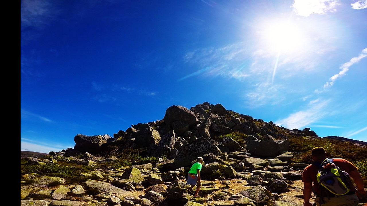
About a mile and a half of straight bouldering, up and over huge ancient stones, placed there seemingly by some giant deity who’s sole cosmic purpose is to prevent an easy ascent to the peak of this mountain. After a bruising climb over the boulder ridge, that you never thought would end, you reach the Tableland.

A man alone on the Tableland is “more lone than you can imagine… She (The Tablelands) seems to say sternly, why came ye here before your time? This ground is not prepared for you. I have never made this soil for thy feet, this air for thy breathing, these rocks for thy neighbors. I cannot pity nor fondle thee here, but forever relentlessly drive thee hence to where I am kind.” Thoreau said that, not me. Believe it or not. I think my quote was more along the lines of “it’s like the moon, but with more green stuff…and gravity.” I’m not on the spot profound as Mr. Thoreau. Around two miles on the Tableland and up one last crest, and you’ve made it. You see the sign, the crowd of people, the complete 360 degree views. There’s a huge cairn (pile of rocks), a wooden sign marking the northern terminus of the Appalachian Trail, and a plaque set into a boulder telling the story of Governor Baxter’s donation of land over 80 years ago.
A quick snack, and it’s time to go down. Back across the Tableland, down the hip/knee/back/ankle crushing boulder slide, down the rocky steps, back across the wooden bridge past the falls, and you’re back at your car.
Katahdin is the quintessential Maine hike. It features everything that makes this state, and it’s people, what it is and what they are, especially the journey from the backbreaking toil and effort needed to crest over the boulder slide and get to the absolutely breathtaking views. A mountain featuring some of the harshest weather you can imagine, shaped and formed by the brutal winters and winds that come every year, it is tested by these conditions as much as it is formed and created into what it is by them. Much like the people of Maine. That is why, as Governor Baxter so perfectly put it, “Katahdin, in all its glory, shall forever remain the mountain of the people of Maine.”
We made it down, all of us, in ten hours. Putting in 10.4 miles in one day is no joke for anybody, nonetheless the motley crew we assembled, who did it with near ease (relatively speaking). I was proud of everyone, and we all got a well-deserved 10+ hours of sleep that night.
Side note, I learned of an interesting “mystery” around Katahdin. Several books reference a poem inscribed on a rock at or near the summit. The poem is as follows;
“Here’s a hail to each flaming dawn
Here’s a cheer to the night that’s gone
May I go a-roamin’ on
Until the day I die”
Nobody knows who wrote it, or where it came from, or where it is now. So if you Internet surfers out there hear anything, you let me know.
I’m going to go plan out my next adventure, perhaps the Bigelow Range Traverse out in Western Maine or the Presidential Range Traverse in New Hampshire. Either way, I’m sure there will be blog posts to follow. I’m kind of into this blog thing for the long haul looks like. In the meantime check out the video I made of the hike here, or go out and hike the mountain yourself. Until the next time, my internet friends.


The quote is from a poem called “A Rolling Stone” by Robert Service. It’s attributed not only to a stone on Katahdin, but on a memorial tablet at Tom’s Rock Camp in the Adirondacks.
http://www.theotherpages.org/poems/service1.html
LikeLike